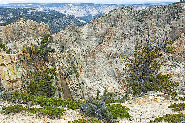
Utah Highway 12, that beautiful All-American Road, connects US 89 west of Bryce Canyon Junction and Utah Highway 24 at Torrey to the northeast. In 1933 the Civilian Conservation Corps (CCC) completed the section between Boulder CIty and Escalante which had previously been traversed by wagons and mules. That same year the CCC began a second road to connect the two towns. Ultimately, this second route became known as the Hell’s Backbone Road, since it follows across Hell’s Backbone Ridge; but the men who built it had a more endearing name, The Poison Road. It is 38 miles long and mostly hardpack dirt and gravel except on either end. About halfway round, the road crosses a chasm over Hell’s Backbone. The bridge that connects the narrow slot is 109′ long and 14′ wide. The railings are low and made of wood.
A focal length of 45mm, quite normal, gave me the angle-of-view I wanted, which isolated a portion of the backbone and the deep chasms time has carved in solid rock. An aperture of f/14 provided depth-of-field, given the camera-to-subject distances present; and a shutter speed of 0.8 second at ISO 100 (As you can estimate, it was an overcast day) gave me an overall medium exposure.
The first time I crossed Hell’s Backbone Bridge it was early-November and there were a couple inches of fresh snow on the ground. Crossing in May with little on the ground other than some new green on the Mormon Tea seemed like a cheerful alternative. Dixie National Forest, though it is the largest national forest in Utah, is an underappreciated natural wonderland of canyons and towering woodlands. It is the headwaters of two major tributaries of the Escalante River. It is another of our special public lands whose preservation is our solemn obligation.
Don, thanks for a neat image and some interesting CCC history. I’ve not been there, and your reference to the Dixie National Forest is a reminder to me I’ve been meaning to look into that name origin, especially in light of our nation’s recent alertness to the residue of an even more oppressive era in our history. It appears on the map that this area is in the National Monument boundaries; is that still true even after the diminishment of that monument? Ray
One thing you did in this picture that I need to get better at is leave out the sky when it does not contribute to the scene. My guess is that it was drab with no clouds. I always feel compelled to include the sky, even if it is only 10%. Need to perish that thought. I like the “V” at the bottom of the scene. It funnels me in and then let’s the “S” curves take over in guiding me through the scene. One question. I generally use f18 or 20 when I am capturing expansive landscapes for even more depth of field. Is there a suggested guideline for that or did you choose it to get the shutter speed you wanted?
Don, as soon as I opened this weeks image my mind went back 6 years to May 18th when you Bonnie and I with four others had the privilege of capturing wonderful views of Hell’s Backbone. Being very familiar with the word stenosis, it brought a smile, as I’d never thought of using it this way. It certainly is appropriate. Some of my favorite images of that trip come from here. Thanks again for taking us back to the Southwest via your image and history.
Good morning Everyone. Thank you all very much for joining me for this conversation. We have a very intimate group of commentators for our discussion of the Devil’s Backbone, so let’s see what we can observe about this beautiful and out-of-the-way spot.
Hi Ray. Thanks very much for being with us and for raising such interesting inquiries about the Dixie. As the material I shared with you would suggest, the name was an acknowledgement of the significant numbers of Mormon converts/settlers who came into Southern Utah at the behest of the leaders of the Latter Day Saints to attempt to grow cotton. The conditions of the area – warm to say the least – and their homes of origin prompted them to begin referring to Southern Utah as “Dixie.”And apparently the National Forest Service went along with the charade. Eventually, other national forests in Southern Utah were merged into the Dixie and it became Utah’s largest federal forestland. Thus there is the suggested identification with the Old South. Could be time for a name change; and, by the way, I appreciate that you like the image. Have a good week and walk in Beauty.
Hey Kev, thanks, as always, for being with us and for sharing such interesting observations. I see that the sky, the foreground, and the depth-of-field (aperture) are on your mind. My approach to the sky in all such landscapes of mine is very simple and I try to live by it absolutely: I ask the question, ‘How much sky does the sky in THIS image merit? How much of a presence has the sky in this image earned by being what it is? My honest answer to that question is the amount of sky that the image will receive. In this instance, the sky was mostly a dull gray/white overcast, and so I felt that it earned almost none/no place in the image. Since I was in a position to eliminate it, I did. I always try to remember that my foreground is the doorway into my image, and if my doorway is effective, my image is off to a very good start. Finally, I determine how much depth-of-field is desirable in my image, then I determine what aperture setting will give me that depth. If there is any question about the depth at the chosen aperture, I stop down, usually a full stop to increase the depth by some amount. This keeps me from automatically going to a small aperture setting just because I can and forces me to be thoughtful about aperture which, in turn, helps me on some occasions gain a faster shutter speed. Hope that’s all helpful. You and Elizabeth be safe and well.
Hey Chuck, It’s great to hear from you, my friend! We certainly had a wonderful adventure on that trip, didn’t we? It was delightful being able to share with you and the others all of those places that have become so special to Bonnie and me. I can still visualize the exhibit you created from that trip. Devil’s Backbone was one of those sideline adventures that can sometimes become as memorable as an iconic location. Take good care and Walk in Beauty.
The Colorado Plateau is a land beyond amazement and all the pictures I can imagine cannot do justice to its Beauty. This is precisely why, in my mind, it is so absolutely essential that all of us do everything we can possibly do to preserve it in tact for all the generations to come. Have a wonderful week Everyone, and be safe.